

 Timely and accurate burned area mapping is essential for designing short-term pre-emptive restoration measures to mitigate the negative impacts (e.g., against floods) and devising efficient short- to mid-term restoration measures as well. It is important for long-term monitoring of changes in order to prevent soil erosion and degradation. Also it is crucial information during the process of declaring the official fire perimeter for reforestation through continuous surveillance to discourage illegal activities. Finally, it is an important for thederivation of statistics for reporting to international institutions (EU, LULUFC, etc.)
Advanced methodology with primary focus on the use of high resolution freely distributed satellite data, providing burned area maps of very high accuracy:
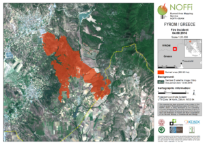
- First ever application of Sentinel-2 data for operational burned area mapping at national level (fire season 2016, Greece)
- Implemented as a QGIS plugin with the following design principles:
- Minimize user interaction: highest possible automation of the process
- Accurate mapping: support official burn perimeter declaration process which is typically done after a fire event by the Forest Service
PARTNERS


![]()