


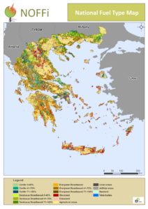
The knowledge of the fuel type’s spatial extent supports the design process of fire prevention, detection and suppression strategies. It constitutes the basic information for fuel reduction treatments while it is used in fire behavior prediction systems (e.g. FARSITE)
An up-to-date mapping methodology has been developed mainly based on the analysis of satellite imagery and the use of existing maps (LPIS-ILOTS, official forest density) as ancillary data. The final fuel type map can be easily update (depends on image availability – no real problem these days) especially after changed due to wildfires, afforestation or clearances. Descriptive criteria can be easily added to discriminate specific classes (sub-urban forests, riparian vegetation etc.). Typical fuel type classification scheme has been used therefore the product is easily comparable with other fuel type mapping products such as the JRC FUELMAP and ArcFUEL.
Basic elements of the developed methodology:
- Winter and summer Landsat 8 OLI images acquired during 2014-15
- Object-based classification approach
- Accuracy assessment based on the LUCAS 2013 survey
Accessible by General Directorate of Forest and Agro-Enviroment Development
PARTNERS


![]()